(Infanta: ESP/PT daughter of a monarch who is a heir to the throne)
Who knows what the history of this community is? It is over 70 kilometers from Swellendam and often overlooked the nature-loving travelers bound for the Garden Route.
It seems that this village is one of the country’s best-kept secrets because few tourists or guides are even aware of its existence, which is quite ironic. After all, this far-flung civilization has a website and ranks on a few Google listings offering services like boat rentals (thanks to its proximity to the Breede River) and holiday accommodations.
Anyway, here is how I got to find out about Infanta. It was in March, during South Africa’s first hard lockdown. My housemate came down with cabin fever and kicked me out. I was under no illusions about anyone taking me in, whether they were family or friends (and much fewer strangers) – thanks to the fear brought on by the pandemic.
I took my bags (a massive, cumbersome duffel, a backpack, and my guitar case, and went to the nearest hardware store to buy a small bow-saw, a machete, and a camping spade. Survival tools in hand, I caught a minibus taxi from Bellville and set off with the idea of finding a place near a river ( I didn’t know where yet).
I looked to Google for answers. Satellite images depicted that Bot River, which was 25 km outside Caledon, was one such place. According to the pictures, it had a river on its outskirts, and its banks were covered in trees.
Bot River
The taxi I took dropped me outside the town three hours before sunset, so I lumbered into the village like a heavily laden mule and walked up the main street. I turned right along an old railway line that intersected the main road and followed it until it curved out of sight from the main road. I went down an embankment into a depression. I hid my bag and guitar under one bush and laid my blanket under the overhang of another. With that done, I dug an Omaha fire hole, which ensured that nobody would see me.
I will never forget the first night: I cooked a corned beef stew, and it was one of the coldest nights I experienced during the month I spent outdoors. The dogs at the neighboring Beaumont winery would not leave me alone. They knew I was there and barked all night. I woke up at five the next morning, covered in frost, and the dogs were still barking.
My day started with me gathering my bags (I was traveling heavy) and slogging back onto the main road. I went in the opposite direction I arrived from the day before. I turned off into the eucalyptus forest on my right. As the sun rose, I hid my duffel and guitar case and headed in the general direction of the river. The idea was; I would find a spot and build a shelter from what I had learned on YouTube’s bushcraft videos.
Getting to the river was tough, and the fynbos almost un-permitting. When I got close to the river, I had to shimmy down a steep embankment that looked and felt like a cliff. When I got down to the banks, its they were narrow and densely wooded, but there was an abundance of human sign indicating that, though by a few, it was frequented regularly. This was not what I had in mind.
After some reflection, I decided that the human factor posed a problem – there was the likelihood that while they were not criminals per se, they could be opportunists, and may decide to harass me. Remaining undetected, and keeping away from humanity was what I perceived to be the secret to my success.
I collected my duffel and guitar case from its stash and trekked back to the N2 Highway, where I hitched a ride that dropped me first in Genadendal and then Villiersdorp. From where I entered the town, it seemed that this last destination was a thriving agricultural community, cultivating, packaging, and shipping apples. It was the next best thing to a small city, and it would not do either.
The people factor during Covid would only result in uncomfortable questions and endanger my endeavors. I backtracked until I found a depression at the side of the road, hid my bag, and found a deep man-made depression about ten meters from the road. It was concealed by the overhang of a tree and two meters below the level of the surroundings. There was a small stream close by and I could tell this by hearing, it but could not see it. On the far side of the depression was an embankment of sorts formed by rubble. That, the dense surrounding foliage, and the depression’s relative depth made my home for the night undetectable from every possible angle.
I ate bread and cold meat and drank a few mouthfuls of water for dinner. After eating, I laid out my blankets and slept like a baby – actually like the dead, never dreaming once that I would get to see a place like Infanta.
A Night in Swellendam
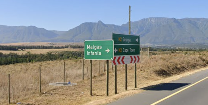
The following morning, I (hitched a ride to the N2) and then further north – past Infanta – to Swellendam, South Africa’s third oldest city, and it was the closest I was to harm during my stint on the road.
3 thoughts on “How I Found Infanta”